How to choose and run a logbook for long distance sailing: position intervals, watch handovers, a paper backup rule, power and updates ashore.
Photo: Tim Marshall, Unsplash
A good logbook for long distance sailing has two parts: something that records the track on its own, and a paper log that holds a position every three hours and each watch handover. On a passage of several days the crew gets tired, power gets rationed and electronics occasionally die, so the log has to survive all three. What follows is how to choose that setup and run it from the first night to landfall.
What a logbook for long distance sailing must cope with
Before choosing a book or an app, go through what the passage will ask of it.
| Demand | What to decide | Sensible default |
|---|---|---|
| Power | How many amp hours per day the log may cost | A phone or tablet on a USB supply, screen off between entries |
| Offline use | Does anything need a signal to save an entry? | It must not. Test in flight mode before you leave |
| Redundancy | What survives if the main device is lost | Paper log plus a handheld GPS with spare batteries in a dry box |
| Watch handover | Where the next watch finds course, sails, traffic and plans | A written handover line at every change |
| Position interval | How often someone writes a position down | Hourly when possible, three-hourly on paper at the minimum |
| People ashore | Who gets updates, how often, and what a missed report means | One named contact with a written plan |
Is a logbook required offshore?
For UK-flagged pleasure vessels, MGN 599 (M) Amendment 1 mentions no logbook duty as of November 2026, and the RYA lists a ship's log as recommended for boats of every size. SOLAS V does apply to small private boats, and its Regulation 34 means planning the passage and making sure someone ashore knows your plans and what to do. A log is the natural place to show you did that.
Other flags have their own rules, so ask your flag authority. In the US, ask the Coast Guard. In Australia and New Zealand, ask your maritime safety authority, particularly before leaving the country, because departure requirements for pleasure craft can apply. Rallies have their own entry rules too, so read them for the ARC or any trans-Tasman event before fitting out.
If an ocean passage will count towards a qualification, plan for that from day one. The RYA Yachtmaster Ocean route asks for a passage of at least 600 miles and 96 hours, with at least 200 of those miles more than 50 miles from land, and candidates submit a narrative account with copies of relevant log pages. Check the current RYA page before you rely on those figures.
Hourly and per-watch routine
A routine that stays small enough to survive a rough third night looks like this.
| When | What the person on watch does | Time |
|---|---|---|
| Every hour | Log time, position or dead reckoning note, course, speed, wind, barometer | One minute |
| Every three hours | Pencil the position onto the paper log and mark the chart | Two minutes |
| Watch change | Write the handover line, then both people read it | Three minutes |
| Any event | Reef, sail change, engine, ship encounter, gear problem | One line, at once |
| Noon UTC | Close the day: distance, fuel, water, barometer trend | Ten minutes |
A handover line that does the job looks like this:
0600 UTC handover: COG 215, 6.2 kn, one reef and full genoa. Wind NW 18, baro 1014 falling 1 per 3 h.
Ship abeam to port at 4 nm, passing clear. Next: shake reef if wind drops below 14. Call skipper if wind above 25.
Every line of that says what the next person needs. The call instruction matters most, because it stops the 0300 question of whether to wake the skipper.
The paper backup: a position every three hours
The reason for three hours is how quickly dead reckoning drifts. Take an example, with assumed errors, at 6 knots over three hours, so 18 miles run.
| Source of error | Assumption | Error after 3 h |
|---|---|---|
| Heading | 3 degrees off | 0.9 nm |
| Unknown current | 0.5 kn | 1.5 nm |
| Speed log | 3 percent | 0.5 nm |
| All three in the same direction | Worst case | 2.9 nm |
After six hours the same assumptions give about 6 miles, and after a day about 24. Three hours keeps the worst case to around three miles, which is close enough to give a usable position in a distress call or to find a landfall on a clear day. It also fits a three-hour watch system, so the position goes down at every handover without an extra task.
Write the position in pencil with the time in UTC, and put a cross on a paper chart or plotting sheet as well. A logged position that has never been drawn on a chart tends to hide transcription errors.
A power budget for the log
Here is an example for a 12-volt boat, with assumed figures. Measure your own gear with a USB meter or your battery monitor.
| Item | Assumption | Per day |
|---|---|---|
| Phone recording around the clock | 1.5 W average | 36 Wh |
| Tablet for entries and charts | 5 W for 3 hours | 15 Wh |
| Low-orbit terminal in two one-hour sessions | 40 W for 2 hours | 80 Wh |
| Subtotal | 131 Wh | |
| With 15 percent conversion loss | 154 Wh, about 13 Ah at 12 V |
Leave that same terminal running all day and it costs 960 Wh on its own. The total climbs to about 1,190 Wh, close to 100 Ah at 12 V, which is why many crews switch it on for scheduled sessions only. A satellite messenger has its own battery, so plan to charge it every few days.
Regular updates for crew and people ashore
"Regular updates" on a passage means two separate things. For the crew it means the handover line and the noon summary. For people ashore it means a position and a short status on an agreed schedule. Write down who the contact is, how often you will report, how late a report may be before anyone worries, and when that person should call the coastguard. Then give them the boat details and the crew list.
A satellite messenger such as an inReach sends positions and short texts through its own network and draws very little from the boat. A low-orbit terminal gives normal internet and video calls, at the power cost above. Either can drop out, so the plan should say that a missed report on its own is no emergency.
Splitting a passage into daily entries
Divide the passage from noon UTC to noon UTC, as ships traditionally do. Each day gets the distance run, average speed, engine hours, fuel and water remaining, weather summary and anything that went wrong. A passage from Las Palmas to St Lucia is roughly 2,700 miles, so at 150 miles a day you are writing 18 of these. Keep a running total against the remaining distance and you will know within a day when your arrival estimate slips.
Keep UTC for the whole passage. Crossing time zones with local time in the log produces days of 25 hours and arguments about when the squall hit.
Different passages stress different parts of the routine.
| Passage | Rough length | What to watch in the log |
|---|---|---|
| Biscay, Falmouth to A Coruña | 450 nm | Shelf-edge sea state, shipping off Ushant and Finisterre, hourly lines near both |
| Atlantic circuit, Canaries to Caribbean | 2,700 nm | Daily run, chafe rounds, fuel and water trends |
| Caribbean to Azores | 2,000 nm plus | Barometer trend and the changing depression track |
| Trans-Tasman | 1,200 nm | Fronts on the way across, and the weather window noted at departure |
| US coastal, Newport to Bermuda | 630 nm | Gulf Stream position and set, with hourly current notes |
Distances are approximate, for planning only.
Long passages in Manta
Manta records the track with your iPhone's GPS, in the background and fully offline, and writes departure, arrival, engine on and off, and anchoring into the log without being asked. With Pro it also logs tacks, gybes and sail changes. Crew on the boat's WiFi can join the same recording and add entries from their own devices (joining is free, hosting needs Pro), and your lock screen has the quick actions for the night watch. A long crossing can be recorded in daily sections and grouped into a tour with its total miles. Live tracking (Pro) shows followers the boat on a web link when there is internet on board; without a connection Manta keeps recording and sends the positions once you are back online.
For the routine on shorter trips, see how to keep a sailing logbook, and the columns are in what to write in a logbook. More on the automatic logbook and live tracking.
Questions
What is the best logbook for long distance sailing?
A combination. An app or plotter records the full track and the routine events, and a paper log holds a position every three hours and the watch handover notes. Either one alone has a way of failing on a long passage.
How often should I log my position on an ocean passage?
Keep a detailed line every hour while the watch can manage it, and write a position on paper at least every three hours. Go back to hourly near land, in shipping lanes and when the weather is changing.
Do I have to keep a logbook on a UK yacht?
As of November 2026, MGN 599 lists no logbook duty for UK pleasure vessels and the RYA lists a ship's log as recommended. The SOLAS V duty to plan your passage does apply. Other flags and rallies can differ, so check with your flag state and read the entry rules.
How do I keep family updated from the middle of an ocean?
A satellite messenger sends positions and short messages. A low-orbit terminal such as Starlink gives you normal internet if your power budget allows it. Agree a schedule and what a missed report means before you leave.
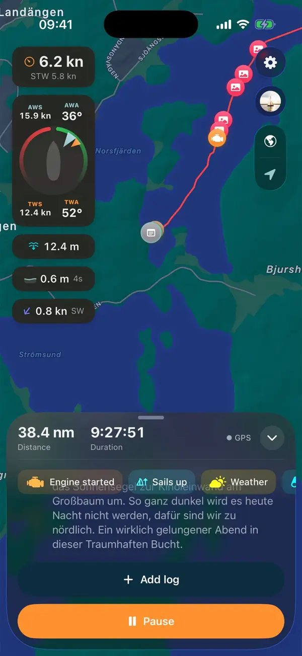
Manta does this for you
Automatic sailing logbook
A digital logbook that fills itself. Manta notices when you cast off, tack, gybe, drop anchor or moor, and writes it into your log by itself. Every automatic entry stays editable.